Over the past five months, researchers using the Mars Odyssey orbiter have been performing a series of listening campaigns near the Martian north pole. The goal was to detect signals that may have been produced by the Phoenix Mars Lander, a spacecraft that arrived at the Red Planet in 2008, but which froze over five months later, due to lack of sunlight. The investigations turned up no results, and now NASA in the end decided to call it quits. It is officially classifying the mission as defunct, and is moving on from allotting additional resources to radio search efforts, Space reports.
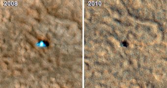
The decision was taken after Phoenix mission controllers from the NASA Jet Propulsion Laboratory (JPL), in Pasadena, California, received a new series of images, collected by another spacecraft. The datasets, captured by the Mars Reconnaissance Orbiter (MRO), show what can be interpreted as extensive damage to the lander's circular solar panels. The new image has been compared with a similar one of the machine, captured after it arrived on Martian soil, two years ago. It is immediately apparent that something is off about the way Phoenix looks like in the second image.
“The Phoenix spacecraft succeeded in its investigations and exceeded its planned lifetime. Although its work is finished, analysis of information from Phoenix's science activities will continue for some time to come,” explains JPL Mars Exploration Program (MER) manager Fuk li. He adds that Phoenix arrived at its destination – the arctic plains of Vastitas Borealis – on May 25, 2008. It immediately began conducting science, digging around itself to prove the existence of water-ice. The mission was successfully achieved, and showed without a doubt that the polar regions on the planet are actually covered with an extensive ice sheet.
“Before and after images are dramatically different. The lander looks smaller, and only a portion of the difference can be explained by accumulation of dust on the lander, which makes its surfaces less distinguishable from surrounding ground,” explains University of Colorado in Boulder (UCB) expert Michael Mellon. He is a member of the science teams coordinating Phoenix, and also the High Resolution Imaging Science Experiment (HiRISE) camera aboard MRO. The instrument was used to snap both images, and so scientists can at least be sure about their source.

 14 DAY TRIAL //