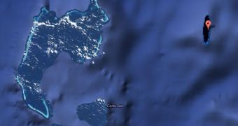
Google Maps is by no means perfect. While Google relies on several official sources as well as the help from its users, mistakes do creep in. It's one thing to misspell a street or misplace a restaurant, it's another to show an entire island that doesn't actually exist.
But that's the case of Sandy Island, a sizeable chunk of land halfway between New Caledonia and Australia that exists only on some maps, including Google's.
The island is marked on some scientific maps and some online ones, but not on navigational maps.
A team from the University of Sydney decided to go there and see for themselves. What they found was the open sea with the ocean floor 1,400m/4,620ft beneath them.
The island is marked on Google Maps, though the satellite image only shows a dark strip, though that's probably because it was marked as an island in the first place.
There's no satellite imagery for the open ocean, instead a rendering of the ocean floor is shown by most online maps.
In places where there's land though, the satellite swoops by and takes a few shots. That's probably what happened here, but since there's no land to photograph, all it got was a few shots of the dark blue ocean.
What's interesting is that Nokia Maps, for example, uses the same satellite imagery, showing a dark strip as well, though Sandy Island is not marked as a location on the regular map. The same is true for Mapquest.
How exactly did this phantom island make its way onto so many maps is a mystery. Most likely, an early error got repeated as new maps relied on the older, wrong data which they assumed was correct.
But even more surprising than the error, perhaps, is the fact that no one noticed it until now. The island, if real, would be quite big, bigger than any of the real islands around it.

 14 DAY TRIAL //