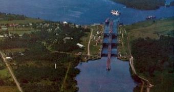
This is the second canal in the world after the Suez Canal (161 km or 100 mi), having a length of 81.3 km (51 mi). The Panama Canal is located on the territory of the state with the same name, connecting the Pacific Ocean and the Atlantic Ocean (via Caribbean Sea).
The idea of digging a canal to cut short the maritime routes between the Pacific and Atlantic Oceans emerged for the first time in the 16th century, after the discovery of the Pacific Ocean by the Spanish expedition led by Balboa, but the idea could not be applied until the 19th century.
The digging, funded by a French company, started in 1881 and was led by Ferdinand de Lesseps, who previously had managed to open the Suez Canal. In 1899, the French company went bankrupt and the digging was continued by US, which took over in exclusivity the right for digging the canal, through a treaty signed in 1901. In 1903, US helped the proclamation of the independent state of Panama, detached from Colombia, achieving instead the sovereignty over the canal and over two land stripes on its both sides, each of them 8 km (5 mi) wide.
The Panama Canal was opened in August, 1914, and it was retroceded to Panama on the 31st of December, 1999, as a consequence of a treaty signed previously, in 1977, by the representatives of both countries.
The Panama Canal is 91-300 m (303-1,000 ft) wide, having a minimal depth of 12.5 m (42 ft). It is built in a hilly area and its construction benefited from the presence of Lake Gatun, which one third of the canal stretches along. Because of the level differences between Lake Gatun and the Pacific and Atlantic Oceans, six locks were built. Ships pass through the locks driven by locomotives.
The first three locks ascend the ships to the level of Gatun Lake (26 m or 87 ft). The other three locks are located on the Pacific side.
Crossing the canal lasts 7-8 hours and is made during daytime only. The most intense traffic is from the Atlantic, and in that part of the canal, the city of Colon developed into the world's second largest free trade zone. The canal is accompanied by a highway, a railway and an oil transporting pipe. The pipe has been functioning since 1982 and it has managed to decrease the traffic through the canal.
Annually, 10,000 ships pass through the Panama Canal, the paid taxes being of about $ 300 million, 10 % of the GNP of Panama.
The Panama Canal has been facing a capacity shortage due to the size of the new cargo ships. The third shipping lane added to the canal will be ready by 2014, 100 years after the opening of the canal, beginning the era of the post-Panamax ships. Panamax is a maritime shipping standard that describes the ships that can fit through the canal's current locks. But with the boom of the commercial exchange between Asia and the Americas, many transporters employ ships 50 % wider than Panamax vessels, carrying 8,000 cargo containers each.
The 5.25-billion-U.S.-dollar widening will add two new three-chamber locks at either end of the canal. The canal would double its annual capacity to over 60 billion cubic ft (1.7 billion cubic meters) of cargo.
Post-Panamax vessels now offload, at ports on the West Coast of the US, goods like Japanese cars, Korean television sets and Chinese toothpaste, which are carried by rail across the U.S. and Canada.
Through the third lane, goods will reach the East Coast ports directly, decreasing retail prices. Brazil and Venezuela, with their rising shipments of oil, grain and other raw materials to China, are also funding the expansion.
The new works face many environmental challenges. The project started with the reforestation of a buffer zone that hugs both sides of the waterway. The new forests act like a sponge and maintain humidity in the area, even in the driest years, not to mention that Panama City takes its drinking water from the canal, storing rainfall during Panama's rainy season and slowly releasing it into the canal during the dry season. Smaller vegetation planted along the canal's banks holds the soil in place. If that soil gets washed away by rains, the sedimentation can fill the canal. Panama isthmus, the bridge between North and South America, is also a migrating route for species of birds and mammals, meanwhile harboring crucial habitats for species like jaguars and eagles.
The canal's current locks dump about 50 million gallons (190 million liters) of water into the sea each time a boat passes through. The main work of the new locks will be the novel water-saving basins.
The basins will fill the lock chambers each time a post-Panamax vessel moves through using state-of-the-art water-pumps. 60 % of the water used on each transit through the new locks will be reused, using actually about 7 % less water than the current locks.
The zone edging the canal is a high-security area where no one is permitted to live. Still, 186,000 people live on islands within the canal or on the banks of the lakes Gatun and Alhajuela, the result of a dam placed farther north.
People living in 20 buildings on the canal's property will have to move due to the fact that, with the new project, the level of Gatun Lake will rise by a few feet, making it occupy 50 % of the length of the canal. Some are worried about the risks of saltwater contamination of the Gatun Lake.

 14 DAY TRIAL //