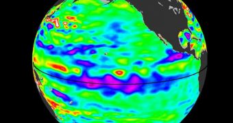
According to investigators at a NASA facility, it would appear that the tropical regions of the Pacific Ocean are currently being cooled by a strong La Niña conditions.
The area was until last winter affected by the El Niño weather pattern, but its influence subsided over the past few months. As a result, this region of the ocean is beginning to cool down.
The conclusions belong to a new study, that was carried out using datasets and readings collected by the US-French oceanography spacecraft Ocean Surface Topography Mission (OSTM)/Jason-2.
“This La Niña has strengthened for the past four months, is strong now and is still building. It will surely impact this coming winter's weather and climate,” says expert Bill Patzert.
The scientist holds an appointment as a climatologist at the NASA Jet Propulsion Laboratory (JPL), in Pasadena. The facility is managed by the California Institute of Technology (Caltech).
“After more than a decade of mostly dry years on the Colorado River watershed and in the American Southwest, and only one normal rain year in the past five years in Southern California, water supplies are dangerously low,” Patzert goes on to say.
“This La Niña could deepen the drought in the already parched Southwest and could also worsen conditions that have fueled Southern California's recent deadly wildfires,” the expert adds.
As the temperature of the tropical Pacific cools, less water will evaporate and make its way into the clouds, which – in the most basic of terms – translates into less precipitations, rain and snow included.
What the OSTM/Jason-2 mission does is keep an eye on sea surface height levels, which are clear indicators to the interplays that develop between El Niño and La Niña events.
These weather patterns are global, in the sense that the changes they instill in the atmosphere have implications on the other side of the world.
“A new image depicts places where the Pacific sea surface height is higher (warmer) than normal as yellow and red, with places where the sea surface is lower (cooler) than normal as blue and purple,” JPL experts write in a press release.
“Green indicates near-normal conditions. Sea surface height is an indicator of how much of the sun's heat is stored in the upper ocean,” they adds.
NASA will continue to keep its satellites trained on the Pacific and the Atlantic oceans over the coming months, in a bid to catch the transition between the two weather patterns in the act.
This may in turn help climatologists develop better conditions of how the La Niña event, which is just starting, will evolve in time.

 14 DAY TRIAL //