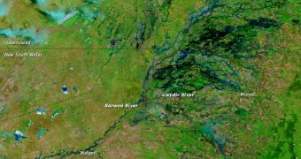
Images collected by the Moderate Resolution Imaging Spectroradiometer (MODIS) instrument aboard the NASA Terra satellite reveals the extent of the floods that affected New South Wales, Australia, this November. The area imaged is usually a rather solid green.
Shades of blue represent flood waters and their depth, while green indicates vegetation cover and light brown represents the soils. The most important rovers in the image are Gwydir River, the Namoi River and the Barwon River.
This particular view of the NSW floods was collected on December 14, about a month after the floods began. The MODIS instrument combined both infrared and visible-light wavelengths to produce this dataset. The photo was made available to the public by the NASA Earth Observatory.

 14 DAY TRIAL //