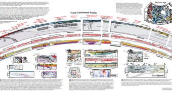
A group of investigators has just released the most comprehensive and detailed map of the foundations on which North America lies to date. The dataset provides an extremely insightful look into the planet's interior, miles beneath the thick continental crust.
Organized as a cut-away map, this view is curved similarly to how the planet curves across the thousands of miles separating the East Coast from the West Coast. The image covers the entire country, from the dangerous Pacific Ocean to the calmer Altantic.
Most of the data included in this view were collected by the Canadian Lithoprobe project, which spent the last 20 years gathering geological, geophysical and geochemical data about what's going on under the continent's surface.
At point, the map dived more than 170 miles (270 kilometers) beneath the crust, providing a view that reaches all the way to the layer of viscous molten rocks surrounding Earth's central core – the mantle.
The Juan de Fuca tectonic plate is the starting point. Located in the Cascadia subduction zone bordering the Pacific Northwest, the area is still very active, and is a part of the Pacific Ring of Fire circling the Pacific Ocean, and extending all the way to Japan and New Zealand.
Some 3,700 miles (6,000 kilometers), the map reaches the Atlantic margin. One of the main conclusions in the study was that the tectonic plates on which the United States and Canada lie are more than 3 billion years old.
Thanks to the wealth of data it includes, the new model provides an unprecedented view on the processes that shaped the continental crust into its current configuration, Our Amazing Planet reports.
“This is the first time anyone's put together a cross-section of a continent with this much detail. [Image resolution] is on the order of a couple hundred meters vertically and a few kilometers laterally, and is even better at shallower depths,” explains scientist Ronald Clowes,.
The expert holds an appointment as a seismologist at the University of British Columbia, in Vancouver. He is also the director of Lithoprobe. Interestingly, he adds, the study also revealed some mysteries.
One of them is why the tectonic plates on which North America lies are so flat at their bottoms. Theoretically speaking, they should have protruding nodes, testifying to the age of the rocks. Yet, such features are unapparent on the new view.
Experts say that future surveys of these interesting regions could shed some light on this enigma. The new work is detailed in the June issue of the esteemed scientific journal GSA Today.
The high-resolution view of the North American continent can be downloaded in .pdf format.

 14 DAY TRIAL //