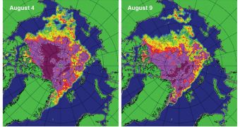
In their latest report, experts at the US National Snow and Ice Data Center (NSIDC) say that weather patterns recorded over the North Pole during this summer were inconsistent with what they expected.
It's not as much that the weather acted differently than usual, it just displayed no consistent pattern. This was made obvious especially between August 4-8, when massive volumes of ice melted.
The phenomenon occurred as an intense storm battered the Arctic. However, experts are currently unsure as to whether any causal link exists between the two. Establishing such a connection is difficult.
Daily ice extents recorded over the first two weeks of August continue to register below 2007's record-low values, the team says, adding that the summer melt season is still five weeks away from ending.
According to the latest data included in the report – collected on August 13 – this year's Arctic sea ice extent was already among the four lowest ever recorded since satellite observations began, in 1979.
Current sea ice extents are about 450,000 square kilometers (173,745 square miles) below the previous record low values, which were recorded in 2007. Only 4.90 million square kilometers (1.9 million square miles) of the Arctic are covered in ice at this point.
Compared to the 1979-2000 average, current levels are 2.81 million square kilometers (1.08 million square miles) lower, the team reports. This difference may increase further over the coming weeks.
“Low extent for the Arctic as a whole is driven by extensive open water on the Atlantic side of the Arctic, the Beaufort Sea, and – due to rapid ice loss over the past two weeks – the East Siberian Sea. Ice is near its normal (1979 to 2000) extent only off the northeastern Greenland coast,” the report says.
The document indicates that air temperature at an altitude of 3,000 feet (914 meters) were between 1 and 3 degrees Celsius (1.8 to 5.4 degrees Fahrenheit) above the 1979-2000 average. This partially accounts for the excessive ice loss over the past two weeks.
“A low pressure system entered the Arctic Ocean from the eastern Siberian coast on August 4 and then strengthened rapidly over the central Arctic Ocean. It persisted over the central Arctic Ocean over the next several days, and slowly dissipated,” the report reveals.
“The storm initially brought warm and very windy conditions to the Chukchi and East Siberian seas (August 5), but low temperatures prevailed later,” the document adds.

 14 DAY TRIAL //