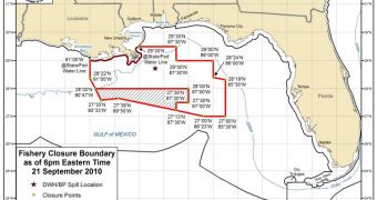
Experts at NOAA announce that they have just reopened a large swath of ocean surface for fishing. The area covers nearly 8,000 square miles, and is now opened for commercial and recreational fishermen.
The region is mostly located alongside the southern border of the federal waters that were closed until now. Federal authorities are collaborating with state authorities on keeping the waters still deemed dangerous sealed.
But the 7,970 square miles that were recently reopened did not exhibit any sort of contamination from the massive oil leak that began on April 22. The Deepwater Horizon drilling rig exploded on April 20.
The reopened area is located about 140 nautical miles off the coasts of Mississippi, Alabama, and the western edge of the Florida panhandle. It is also located 60 nautical miles off central Louisiana.
Experts at the US National Oceanic and Atmospheric Administration (NOAA), the main federal authority keeping the situation in the Gulf of Mexico under control, say that this is the sixth reopening that was agreed upon since July 22.
“This area is significant to commercial and recreational fishermen who target tunas and billfish that migrate far and wide and provide an important source of income and sport,” explains the NOAA Administrator, Jane Lubchenco, PhD.
“We’ll continue to work with our partners at FDA and the Gulf states to ensure our Gulf seafood is safe, so we can reopen more areas to fishing,” adds the official, who is also the US under secretary of commerce for oceans and atmosphere.
The decision to reopen this swath of ocean surface was taken by experts at NOAA, the US Food and Drug Administration (FDA), and representatives from all affected Gulf states.
The area that was now targeted by the discussions covers an estimated 3 percent of all federal waters in the Gulf, and represents about 20 percent of the previously-closed area.
“No oil or sheen has been documented in the area since July 21. At its closest point, the area to be reopened is about 50 statute miles south of the Deepwater/BP wellhead,” NOAA says.
“Sensory analyses of 93 samples and chemical analyses of 92 samples in 18 composites followed the methodology and procedures in the re-opening protocol, with sensory analysis finding no detectable oil or dispersant odors or flavors, and results of chemical analysis well below the levels of concern,” experts add.
In the new investigation, scientists focused on fish such as tuna and billfish. The agency says that it will continue with its efforts of monitoring the situation.
The area that is currently closed for fishing will suffer modifications depending on how the situation evolves, researchers conclude.

 14 DAY TRIAL //