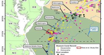
A collaboration of researchers from multiple government agencies set out on June 4 on an expedition meant to analyze and map the deepwater canyons that exist at the bottom of the Atlantic Ocean.
The research effort will be focused on an areas about 100 miles off the coast of Virginia and Maryland, where many of these canyons are known to be located. The expedition will conclude shortly, on June 17, when the research vessel will return to port.
In addition to creating the actual maps, the sonars will also contribute to identifying sensitive biological habitats, key coral communities and archaeological sites, including for example old shipwrecks.
The study is being conducted as a part of the National Policy for the Stewardship of the Oceans, Our Coasts and Great Lakes, which US President Barack Obama signed into law in July, 2010.
Scientists from the US Geological Survey (USGS), the National Oceanic and Atmospheric Administration (NOAA), and the Bureau of Ocean Energy, Regulation and Enforcement (BOEMRE) are involved in the research, which is carried out from aboard the NOAA research ship Nancy Foster.
The 3D bathymetric seafloor maps the team set out to produce will be obtained by scanning the ocean floors with a sonar-based imaging method called echo-sounding. In follow-up expeditions scheduled to take place over the next 24 months, experts will analyze any interesting feature discovered.
The Nancy Foster set sail on June 4 from Charleston, South Carolina. Each of the three agencies will contribute about 3 million dollars over the course of their three-year collaboration. This is only the first of several joint-agency partnerships.
“Commemorating 10 years of ocean exploration, NOAA’s Office of Ocean Exploration and Research uses state-of-the-art technologies to explore the Earth's largely unknown ocean in all its dimensions for the purpose of discovery and the advancement of knowledge,” a NOAA press release reads.
“NOAA’s mission is to understand and predict changes in the Earth’s environment, from the depths of the ocean to the surface of the Sun, and to conserve and manage our coastal and marine resources,” the statement goes on to say.
Through the National Oceanographic Partnership Program (NOPP), the three governmental agencies seek to increase cooperation in this field of research, while at the same time minimizing the costs generally associated with conducting such investigations.

 14 DAY TRIAL //