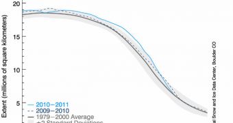
According to a new analysis released by experts at the US National Snow and Ice Data Center (NSIDC), it would appear that the extent of sea ice in the Arctic for December 2010 was the lowest for this month in satellite record.
Climate experts appear to believe the a strong negative phase of the Arctic Oscillation may be responsible for this situation, which exerts a huge threat for the North Pole and all the species depending on the ice for their very survival.
Official data show that sea ice extent was unusually low in both the Atlantic and Pacific sides of the Arctic, reaching an average of 12.00 million square kilometers (4.63 million square miles).
This is the lowest amount of sea ice at the North Pole in satellite record, which spans back to 1979. The previous record for the lowest extent was set in the winter of 2006, when only 12.27 million square kilometers (4.74 million square miles) of the Arctic were frozen over.
Three critical areas – the Hudson Bay, the Hudson Strait and the Davis Strait – were not completely frozen over in December, as is usually the case. In fact, they generally freeze in late November.
“The low ice conditions in December occurred in conjunction with above-average air temperatures in regions where ice would normally expand at this time of year,” NSIDC experts say.
“Air temperatures over eastern Siberia were 6 to 10 degrees Celsius (11 to 18 degrees Fahrenheit) above normal in December,” they add in a press release.
“The warm temperatures in December came from two sources: unfrozen areas of the ocean continued to release heat to the atmosphere, and an unusual circulation pattern brought warm air into the Arctic from the south,” the team goes on to sa.
Throughout December 2010, the middle and high latitudes of the Northern hemisphere were dominated by a strongly negative phase of the Arctic Oscillation (AO), a phenomenon that also took place in the winter of 2009, experts say.
The AO can best be defined as the dominant pattern of non-seasonal sea-level pressure variations that take place above 20 degrees Northern latitude. This oscillation can be predicted by analyzing weather phenomena taking place thousands of miles away, scientists say.
“2010 started out with a highly negative phase of the Arctic Oscillation, an atmospheric pattern that in the past has favored the survival of old ice through the winter, and more ice at the end of this summer. But this tendency seems to be changing,” experts add.
“A recent study led by Julienne Strove of NSIDC showed that while wind patterns linked with the strongly negative Arctic Oscillation winter of 2009-2010 transported much old ice into the southern Beaufort and Chukchi Seas, most of this ice later melted,” the group concludes.

 14 DAY TRIAL //