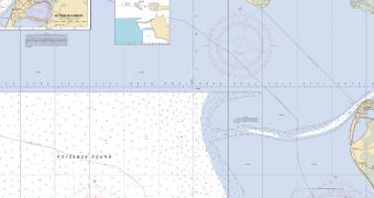
As global warming is leading to the loss of more and more ice in the Arctic, new shipping routes are becoming available in areas where ice has previously made traffic impossible. Officials at the US National Oceanic and Atmospheric Administration (NOAA) will soon release a map of such an area.
Their new nautical chart covers a region known as Kotzebue Sound, which is located in the Alaskan portion of the Arctic. This area has never been properly charted before, primarily because very few ships ventured here throughout the year.
As the Sound is becoming increasingly devoid of ice for most of the year, ships are beginning to use the area for regular transits, which increases the risk of a maritime accident occurring. Thanks to the new map, which NOAA plans to release by the end of the month, this potential risk is now lower.
Experts at the federal agency used the hydrographic survey ship Fairweather to conduct a full survey of the ocean bottom in the summer of 2011. A full range of depth measurements was conducted, and a large number of objects on the ocean floor detected. All these data are included in the map.
Before this dataset, the most recent map for Kotzebue Sound dated back to the 19th century and included depth measurements taken between 3 to 5 miles (5 to 8 kilometers) apart. This means that objects located in between these sites still posed a danger to navigation.
“This new chart is just one of the many critical navigational services that NOAA provides to support safe navigation and maritime commerce while protecting important marine resources,” explains Kathryn D. Sullivan, PhD.
She holds an appointment as the deputy administrator of NOAA, and is also an assistant secretary of commerce for environmental observation and prediction.
“Based on stakeholder discussions and developing Arctic vessel traffic patterns, NOAA will improve the existing charts and navigational data to position the regional maritime economy to meet emerging opportunities, as we expand our commerce and energy sectors into the Arctic region,” she adds.
Sullivan was the one who presented Alaska Lt. Governor Mead Treadwell with the new map, during a Hydrographic Services Review Panel meeting that NOAA has recently organized in Anchorage.

 14 DAY TRIAL //