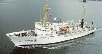
As global warming catches on speed and continues to advance, one of its primary effects is causing the Arctic ice caps to recede. As this happens, new waters become available for navigation, but these waters have not been charted for at least 50 years, and so their hazards are very little known. Responding to the need to map these areas, the US National Oceanic and Atmospheric Administration (NOAA) recently dispatched one of its top ships, the Fairwearther, to image the bottom of Arctic waters.
The recession of ices may be a catastrophe for global weather patterns and local animals, but they also represent a new source of income for various countries and corporations. Nations are very interested in finding new channels of communications between various regions of the world through the North Pole. If navigational routes can be established, then travel times between the corners of the world could be reduced, which would mean lower transport costs, and lower overall prices. But ships cannot be sent in uncharted waters, and its the job of the Fairweather to ensure that the maps of the bottom are the most accurate possible.
“We have seen a substantial increase in activity in the region and ships are operating with woefully outdated charts. I have introduced legislation that authorizes a significant increase in funding for mapping the Arctic, and I am pleased to see NOAA beginning the process. While this is a good start, we still need more resources to adequately map this region,” Sen. Lisa Murkowski of Alaska believes. “Commercial shippers aren’t the only ones needing assurances of safety in new trade routes. The additional potential for passenger cruises, commercial fishing and other economic activities add to pressures for adequate response to navigational risks,” adds the director of the NOAA Office of Coast Survey, Captain John Lowell.
The Fairweather currently operates in the Bering Straits around Cape Prince of Wales. It began its cruise in July, and will finish it in August. For two months, it will analyze seafloor features, produce seafloor depth charts, and update nautical charts for an area of about 350 square miles. “In Alaska we are seeing the effects of climate change more rapidly than anywhere else in the US. As Arctic sea ice recedes, economic activity in the region is going to expand dramatically. Alaskans rely on NOAA to help us make sure that things like oil and gas development and marine transportation are done safely and responsibly,” Sen. Mark Begich of Alaska concludes.

 14 DAY TRIAL //