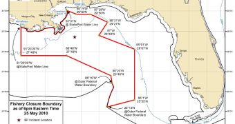
Experts at the US National Oceanic and Atmospheric Administration (NOAA) announce that they have extended the area where fishing is currently forbidden in the Gulf of Mexico. With the oil slick caused by the Deepwater Horizon drilling rig accident on April 20, fishing has now become unsafe in the region, authorities say, and fishermen are therefore forbidden to catch their usual stocks there. A map of the closed-down area accompanies this article. For a larger version, visit NOAA's website here.
“NOAA has extended the closed fishing area in the Gulf of Mexico to match the Louisiana state waters closure west of the current boundaries, and to incorporate an area reportedly with oil in the southwest. Closing fishing in these areas is a precautionary measure to ensure that seafood from the Gulf will remain safe for consumers. The closed area now represents 54,096 square miles, which is slightly more than 22 percent of Gulf of Mexico federal waters. This leaves more than 77 percent of Gulf federal waters still available for fishing. The closure will be effective at 6:00 pm EDT,” officials write in a statement released to the press.
Both federal and state authorities will ensure that people do not breach the containment zone. Catching, preparing and selling products derived from marine wildlife exposed to oil contamination is strictly forbidden for public health concerns, and those caught breaking the law will be severely punished. In order to ensure that no outbreaks or poisonings happen, NOAA is working in close collaboration with the US Food and Drug Administration (FDA), to constantly test the quality of seafoods reaching supermarkets and shores in the areas adjacent to the site of the disaster.
“[…] there are approximately 5.7 million recreational fishermen in the Gulf of Mexico region who took 25 million fishing trips in 2008. Commercial fishermen in the Gulf harvested more than one billion pounds of fish and shellfish in 2008. NOAA will continue to evaluate the need for fisheries closures based on the evolving nature of the spill and will re-open closed areas as appropriate. NOAA will also re-evaluate the closure areas as new information that would change the boundaries of these closed areas becomes available,” the press release further reads.
The closed-off areas could be extended, however. Just recently, oceanographers have announced the discovery of a large underwater plume in the Gulf of Mexico, in the immediate vicinity of the Deepwater Horizon accident. They say that the formation is not visible from the surface, and that it is most likely made up of oil. If future results confirm this finding, then it would mean that environmentalists' worst fears have realized. These plumes could prove that the extent of the damage caused by the three ruptured wellheads is even larger than thought. There is also no way of telling which way they will spread, experts say.
Since April 20, when the semi-submersible drilling rig exploded, killing 11, thousands of barrels of crude oil have been leaking into the waters of the Gulf of Mexico. The oil slick has extended considerably in the month that passed, and now threatens delicate coastal areas. The underwater plumes may have already entered the Loop Current, which is a deep-water current that heads east, towards Florida, and then even further, into the Gulf Stream. Since April 22, when the rig sunk, British Petroleum, the company in charge of operating the platform, has been struggling to contain the situation with federal help, but thus far efforts have been in vain.

 14 DAY TRIAL //