Scientists are very interested in determining the exact spots where migratory birds make pit stops on their way from the boreal forests of Canada and New England to various locations in Central and South America. For this purpose, they enlisted the help of NASA.
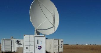
The American space agency is contributing with a series of ground radars, which it normally uses to monitor precipitations. The data are used to validate the performances of orbital satellites assessing the same thing from hundreds of miles above the surface.
Interestingly, University of Delaware radar ornithologist Jeff Buler explains, these radars see birds as large sacks of water. The instruments are fine-tuned to observe small drops of water falling to the ground over very large areas around them.
Experts know that a multitude of birds currently take flight from the lower Delmarva Peninsula, near Oyster, Virginia, and so they decided to carry out a new investigation here. What scientists are particularly interested in is determining birds' migration patterns along the East Coast.
They hope that finding out where the birds stop to rest will eventually aid them in their conservation efforts. For this purpose, they are using a facility that NASA set up as part of its Precipitation Science program. The installation is located in the Virginia Coast Reserve (VCR).
The Nature Conservancy has recently made a deal with NASA, which enables it to use the advanced capabilities of the agency's Polarimetric (NPOL) weather radar at the VCR. The organization is working with experts from the Old Dominion University and the University of Delaware for the study.
“Radar gives us a way to map their distributions over large spatial scales because essentially these radars detect the birds as they take off. You just get this explosion of birds flying up into the radar and it basically gives us a snapshot of where they occur on the ground,” Buler explains.
Unlike conventional radars, which have a hard time distinguishing between biological signatures such as those given off by insects, bats and birds, NPOL instruments are extremely sensitive, and can be used to tell these creatures apart.
Once the stopover locations are identified, researchers will travel to these spots, and survey the type and number of birds that use the sites. This will give them a better idea of how to conduct future conservation efforts.

 14 DAY TRIAL //