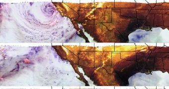
NASA scientists at the Goddard Space Flight Center in Greenbelt, Maryland, announce that they are tracking the progress and evolution of a large storm system that affected the state of California in late February and on March 1. The clouds are heading eastwards, but they are under constant surveillance by the NASA Tropical Rainfall Measuring Mission (TRMM) satellite.
The four images above (click for full resolution) were collected by the Microwave Imager (TMI) on the TRMM satellite. They were snapped on February 28, and March 1, 2, and 3, and show how the storm system moved from the West Coast nearly all the way to the East Coast.
TMI captured these images at microwave frequencies, of 85.5 GHz and 37 GHz, respectively. The composite false-color photos feature red, green, and blue components, says GSFC investigator Hal Pierce, who is a member of the TRMM science mission. Grey and white code for snow covers, green for deserts, yellow for light scattered by cloud ice, and blue for dry atmosphere over water.
The TRMM mission is a joint effort by NASA and the Japan Aerospace Exploration Agency (JAXA). The satellite was launched into space from the Tanegashima Space Center in Tanegashima, Japan, on November 27, 1997. A follow-up mission has been launched just days ago, the NASA/JAXA Global Precipitation Measurement (GPM) Core Observatory.

 14 DAY TRIAL //