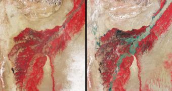
Using data collected via its Earth-observing satellites, the American space agency is currently piecing together a clear picture of what happened just before, during and after the massive wave of floods that affected Pakistan in late July 2010.
According to official statistics, it would appear that about 20 percent of the entire surface of Pakistan was affected by the floods. More than 1,500 people have been killed by the waters, according to figures quoted by the Associated Press.
The unleashed elements razed tens of thousands of villages, and left countless homeless. The disastrous situation is not expected to improve until the end of this month, when the waters will finally begin to recede.
The floods were caused by incredibly heavy monsoon rains, which increased the flow rate of most major rivers in the country, leading to the catastrophe.
According to NASA, storms such as the ones that affected the Asian nation were not at all uncommon this season. The agency says that, most likely, they were caused by a combination of excessive tropical monsoon moisture combining with a strengthening La Nina event.
This combination apparently dominates global weather patters, as La Nina is an atmospheric event that is affecting the entire world.
Data collected by the CloudSat satellite reveal that, between July 28 and 29, no less than 400 millimeters (16 inches) of water fell from the skies above Pakistan.
This led to the Indus and Kabul rivers swelling up beyond recognition, and flooding everything in their path, experts at the NASA Jet Propulsion Laboratory (JPL), in Pasadena, California, report.
The attached image pair shows perspective views of the flooding that took place in Pakistan. The photographs were taken approximately one year apart.
The observations were carried out with the Multi-angle Imaging Spectroradiometer (MISR) instrument aboard NASA's Terra spacecraft. The first image was taken on August 8, 2009, while the second one was snapped on August 11 2010.
The colors in the two images distinctly highlight the contrast that develops between water and vegetation on the river banks, as viewed from the satellite.
The contrast is augmented by the fact that vegetation appears bright in the near-infrared portion of the electromagnetic spectrum.

 14 DAY TRIAL //