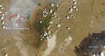
Using the Moderate-Resolution Imaging Spectroradiometer (MODIS) instrument on its Aqua satellite, the American space agency recently produced this amazing image of brush fires in eastern Oregon.
While some of these fires have been burning for a while, others were only discovered less than a week ago. NASA determined that very high temperatures and strong gusts of wind were primarily responsible for how fast the fires spread.
The Long Draw Fire, for example, was produced by a lightning strike on July 8, and originated some 10 miles (16 kilometers) west of Basque. Though 30 percent contained, it still managed to singe around 455,029 acres (1,841 square kilometers) of land.
NASA is continuously monitoring the spread of wildfires across the United States, providing local and federal authorities with up-to-date satellite imagery of the affected areas.

 14 DAY TRIAL //