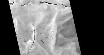
Scientists at NASA announce that they have just recently obtained a new photograph showing the extent of the damage caused by the oil spill currently taking place in the Gulf of Mexico. While numerous other satellite images of the disaster have been taken, the new one, snapped on May 7, is different because it was collected during the night, and in infrared wavelengths. This allows experts to gain additional data on how the oil slick is spreading, as well as on which regions are most at risk.
The Terra spacecraft was used for this new task. Its main instrument, the Advanced Spaceborne Thermal Emission and Reflection Radiometer (ASTER) is extremely efficient in conducting such surveys, and its managers exploited its capabilities to the fullest, say experts at the NASA Jet Propulsion Laboratory (JPL) in Pasadena, California. With ASTER, the oil slick was seen in a new light, which again highlights the incredible devastation caused by the April 20 explosion of the Deepwater Horizon semi-submersible oil rig.
Since April 22, when the massive structure sank into the waters of the Gulf, killing 11 workers, more than 5,000 barrels of oil have spilled into the water per day. According to officials in charge of the clean-up effort, there were three main leaks in the deposit below the surface. One of them, the smallest, was covered up yesterday. Vessels belonging to BP, the company that operated the rig, lowered a massive concrete bell onto the ocean floor, covering the oil source. However, an additional two, larger sources remain, and their combined output still threatens the delicate coastlines of Louisiana, Alabama and Mississippi.
“This thermal image from ASTER covers an area measuring 60 by 240 kilometers (37 by 147 miles), most of it over the Gulf of Mexico. The coldest surfaces appear dark, and the warmest appear white. Offshore islands below Pascagoula also appear dark compared to the surrounding ocean. The black dots and patches over the Gulf waters are small clouds, particularly in the southern half of the image. The thickest parts of the oil spill appear as dark gray, filamentous masses in the southern part of the image, extending off the bottom. Other dark-light swirl patterns are water currents where different temperature water masses are visible,” the JPL experts write in a press release on their website.

 14 DAY TRIAL //