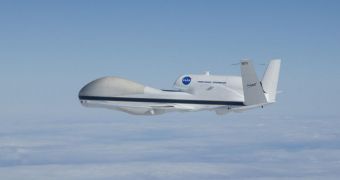
Both Global Hawk Unmanned Aerial Vehicles (UAV) at NASA will be used in early September during the agency's Hurricane Severe Storm Sentinel Mission (HS3). They will conduct a couple of high-altitude, long-duration, unmanned flights over the most severe tropical storms of the season.
According to meteorologists, the peak of the hurricane season is usually recorded in September, so this is when HS3 will begin. Each Global Hawk will be carrying a different set of scientific instruments, and will focus its flight on a specific set of atmospheric parameters.
The “severe storm sentinels,” as the two UAV are known, are controlled by two pilots, one in Wallops, Virginia, at the NASA Wallops Flight Facility, and another at the agency's Dryden Flight Research Center, near Edwards Air Force Base (EAFB), in California.
These Global Hawks are not standard issue. They have been heavily modified for weather investigations, and are able to fly at altitudes of up to 60,000 feet (18,290 meters), for up to 28 hours. This means that they can fly over hurricanes for much longer periods of time than human pilots can.
Tropical storms commonly reach altitudes of up to 50,000 feet (15,240 meters), and cover an area of thousands of square miles. This makes for an extremely rough environment for human pilots, but also the perfect setting for using UAV.
“Several NASA centers are joining federal and university partners in the Hurricane and Severe Storm Sentinel (HS3) airborne mission targeted to investigate the processes that underlie hurricane formation and intensity change in the Atlantic Ocean basin,” scientist Scott Braun says.
He is the principal investigator for the HS3 mission, and also a research meteorologist at the NASA Goddard Space Flight Center (GSFC), in Greenbelt, Maryland. Braun says that the Global Hawks will study atmospheric winds, temperature, humidity, precipitation, and aerosol profiles.
The first Global Hawk is called UAV No. 872, and it will carry three scientific instruments – the Cloud Physics Lidar (CPL), the Scanning High-resolution Interferometer Sounder (S-HIS) and a dropsonde system that will measure winds, temperature and humidity.
The second Global Hawk, UAV No. 871, carries the High-Altitude MMIC Sounding Radiometer (HAMSR), the High-altitude Imaging Wind & Rain Airborne Profiler (HIWRAP) radar and the Hurricane Imaging Radiometer (HIRAD).
According to NASA, the Wallops Flight Facility will be the base of operations for both UAV during their HS3 flights, this September.

 14 DAY TRIAL //