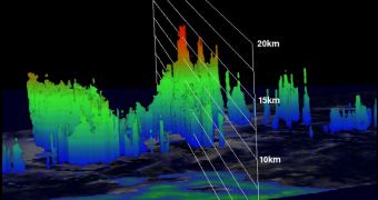
One of NASA's two Global Hawk Unmanned Aerial Vehicles (UAV) was deployed from the agency's Wallops Flight Facility, on Wallops Island, Virginia yesterday, September 11, to study Tropical Depression 14. Scientists believe a new tropical storm may originate from this formation.
The two Global Hawk aircraft NASA operates for its Hurricane and Severe Storm Sentinel (HS3) airborne mission were designed, built and modified by the Northrop Grumman Corporation.
Each of them can remain airborne for around 28 hours, flying at altitudes of up to 18,288 meters (60,000 feet). They are controlled from special operations centers at both Wallops and the NASA Dryden Flight Research Center, near Edwards Air Force Base, in California.
A couple of days ago, scientists monitoring the central Atlantic Ocean saw a new tropical depression forming. Called TD 14, the formation is believed to be on its way towards developing into a tropical storm, potentially even a hurricane later on.
The Global Hawk was deployed because the very purpose of HS3 is to gain a deeper understanding of what makes these weather events tick. Another goal is figuring out what makes these storms more likely to intensify or subside.
These data may lead to the development of better predictive models of future hurricanes, potentially contributing to saving lives and avoiding extensive property damage.
The Global Hawk took off at 7:06 am EDT (1106 GMT), and is scheduled to remain airborne for 26 hours, says the manager of the NASA Global Hawk program, Chris Naftel, who is based at Dryden.
“At 1500 UTC (11 am EDT), Tropical Depression 14 was located near 16.3 North latitude and 43.1 West longitude, about 1,210 miles (1,950 km) east of the Lesser Antilles. The depression had maximum sustained winds near 35 mph” (56.3 kilometers per hour), NASA experts report.
“The National Hurricane Center expects Tropical Depression 14 to strengthen into a tropical storm over the next 48 hours, and turn to the northwest,” the team adds.
The NASA Tropical Rainfall Measuring Mission (TRMM) satellite also flew over TD 14, on September 10. It used its Microwave Imager (TMI) and Precipitation Radar (PR) instruments to develop a profile of the formation.

 14 DAY TRIAL //