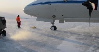
This Monday, March 14, the American space agency embarked on the 2011 iteration of its famous IceBridge Mission, which seeks to determine the state of the polar ice caps all over the world.
This year's endeavors will be focused in the Arctic, especially in northern Canada. At the same time, all participants will attempt to expand their international collaborations with other researchers and experts.
On Monday, researchers and their pilots arrived in Thule, Greenland, to prepare for the beginning of this year's scientific expedition. Everyone is ready to go on a new adventure, and excited about the outcomes of this thorough investigation.
The mission is entirely airborne. Special purpose airplanes have been outfitted with the necessary equipment to conduct a wide variety of tests and measurements on the ice caps near the North Pole.
Climate scientists say that it's absolutely critical to keep an eye on polar ice sheets, glaciers and sea ice all around the world. Using these observations, they can accurately refine existing climate models, and determine how global warming will affect the planet in the future.
In this sense, IceBridge is a part of the pledge NASA made to help keep an eye on the effects of climate change on polar ices at both the North and South Poles, and in Greenland. These areas contain most of the planet's ice reserves.
Experts with the study – which began in 2009 – usually start collecting data over the Arctic in early March. Once the season ends, they move to the South Pole, and begin flying over the Antarctic in October. This enables the team to get a planet-wide view on things each year.
As a result, NASA is augmenting its ability to maintain multi-year records on ice elevations. These datasets were initiated by readings collected with the Ice Cloud and land Elevation Satellite (ICESat).
The mission stopped collecting new information in 2009, and its replacement, ICESat-2, won't be launched until 2016. In the mean time, NASA wants to ensure that it will not lose constant monitoring capabilities over these sensitive areas.
“Each successive IceBridge campaign has broadened in scope. This year, we have more flight hours and flight plans than ever before. We are looking forward to a busy, fruitful campaign,” says expert Michael Studinger.
The expert, an IceBridge project scientist, is based at the University of Maryland in Baltimore County (UMBC) Goddard Earth Sciences and Technology Center. He explains that the actual flights will begin this week, and that the 2011Arctic campaign will last for about 10 weeks.
“The Canadian ice caps are notably smaller than the Greenland and Antarctic ice sheets, but are still significant potential contributors to sea-level change in the next few decades,” adds Charles Webb.
“They also serve as potential early-warning indicators, responding more sensitively to temperature changes than the more massive ice sheets,” says the expert, who is the deputy cryosphere program manager at the NASA Goddard Space Flight Center (GSFC), in Greenbelt, Maryland.

 14 DAY TRIAL //