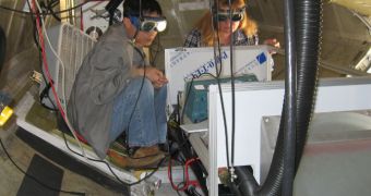
A team of experts with the NASA Goddard Space Flight Center (GSFC), in Greenbelt, Maryland, carried out a new series of investigations and flight tests. During the experiments, experts assessed the performances of a new type of LIDAR technology.
LIDAR, short for Light Detection And Ranging, is an optical ranging technology system in which a laser beam is used to measure the distance between the light source and an object. This has numerous applications, from urban planning to bomb disposal and space exploration.
The new type of LIDAR is destined to go on satellites that will monitor our planet. Like many other instruments that go on NASA spacecraft, they are at first flown aboard aircraft the American space agency operates.
These test flights are part of the NASA Airborne Science Program, and they are meant to validate the devices, and demonstrate that they work. This eliminates the risk of a failed instrument making its way into Earth's orbit.
Using one of NASA’s DC-8 flying laboratories, the GSFC has been conducting its tests for over three weeks now. The investigation is conducted by Goddard scientist Bill Heaps, and is focused on determining the performances of a new broadband LIDAR instrument.
The device is scheduled to launch to space aboard the NASA Active Sensing of Carbon dioxide Emissions over Nights, Days and Seasons (ASCENDS) satellite, which is currently scheduled for deployment around 2018-2020.
According to officials at the space agency, this mission will have a very specific and delicate objective, which is to measure the global sources, distribution and variations of carbon dioxide gas (C02) with tremendous precision and accuracy.
The DC-8 based tests yielded incredible results thus far, and the GSFC team is very satisfied with the way the device is coming along. “The system definitely measured CO2 on both flights, even transmitting a very small amount of laser power,” Heaps explains.
“I believe the broadband technique has excellent potential to be scaled up for measurements from space,” the team leader goes on to say. The expert reveals this LIDAR uses an infrared laser beam.
He explains that the DC-8 he and his team are currently using as a test platform has been outfitted with the new instrument about five weeks ago, at a special facility located at the NASA Dryden Aircraft Operations Facility, in Palmdale, California.

 14 DAY TRIAL //