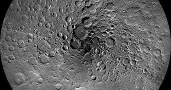
Using data from a spacecraft in orbit around Earth's natural satellite, researchers at the American space agency announce the creation of the first high-resolution, highly-detailed map of the lunar north pole.
The area, now visible in a manner that cannot be observed from the surface of the planet directly, has been under constant monitoring from the NASA Lunar Reconnaissance Orbiter (LRO) for the last couple of years. During this time, the spacecraft has snapped numerous pictures.
According to the official number, 983 photographs have been pieced together to create this amazing view of the Moon's northern hemisphere, centered on the pole itself. The new dataset goes a long way towards helping astronomers get the most comprehensive view of the satellite possible,
Even though nearly a thousand images made it into the final cut, thousands more were snapped by the wide-angle camera aboard the LRO. While they were not included in the final composite view, they did contribute significantly towards understanding various smaller features on the lunar surface.
One of the primary objectives for the space probe was identifying permanently-shadowed areas of the Moon. These areas appear because the celestial body only tilts at an angle of 1.54 degrees on its axis, compared to Earth's tilt of 23.5 degrees.
An immediate consequence is that some areas never get to see the light of day. They are very important to scientists because they can reveal more about the Moon's history, but also because they hold the most precious resource there, water-ice.
The chemical can be used to produce drinking water, oxygen and hydrogen-based rocket fuels for manned space exploration missions to the space body. Exploiting these water-ice reserves could lead to astronomers establishing a more permanent presence there.
In the mean time, the LRO is laying down the necessary groundwork for future missions. It very purpose is to image the lunar surface, identifying areas that allow spacecraft landings, while simultaneously being close to potential resource areas.
The north pole is shaping up to be one of the leading candidates, even though it has the major drawback of featuring very rough terrain. Still, discovering water-ice here is more probable than at lower latitudes, or even the south pole.
Interestingly, the image appears to display a spiral of craters moving out of the pole itself. This is nothing but an illusion, Arizona State University expert and LRO principal investigator Mark Robinson explains.
“Imagine a series of very narrow pie slices collected 12 times each day, one after another. It takes roughly 360 slices to fill in the whole pie,” he explains, quoted by Space.
“Each day the sun direction is progressing around the Moon, thus the direction that the Sun is striking the surface changes. So the shadow directions slowly progress around the moon, thus leading to the illusion,” he concludes.

 14 DAY TRIAL //