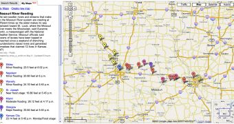
Google recently introduced My Maps, an exciting function that allows users to create their own projects based on Google Maps. Although the creation of the Google Maps mash-up was quite successful, this new function offered more power to the developers and helped them build more attractive products. Today, the Mountain View company presented the most impressive projects based on Google Maps and published on the Internet. For example, Google sustained the Missouri Flood map used to present the torrential rain was quite useful and provided relevant information about the damaged areas. "Torrential rain caused levees to break along the Missouri River near Kansas City, claiming 12 lives. This map includes flood forecasts, water level information, and hydrographs for the communities affected by the floods," Google said.
Since the release of the feature, numerous developers were attracted by Google Maps to build their own projects and publish them on the Internet. However, the online service is probably one of the most important products ever designed by the search giant, a statement also sustained by the recent updates implemented in the service. As you might know, Google silently introduced several imagery improvements, adding new detailed street pictures from countries all around the world.
The downloadable version of Google Maps, Google Earth, was also updated and released as a new beta version that brings more power to its users. Although the company didn't announce it officially, Google Earth 4.1 beta was quietly introduced on the Internet and contains several new features. For example, you're now able to view a certain location straight on Google Maps using your web browser by pressing a simple button in Google Earth. The search giant also updated the application with tips, useful messages that are displayed just after the user starts the program and connects to the main screen.

 14 DAY TRIAL //