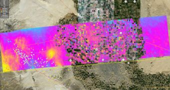
Scientists with the NASA Jet Propulsion Laboratory (JPL), in Pasadena, California, announce that their latest investigations of the border areas between Mexico and the United States show that the planet's crust is still deforming in the area. They say that this is a direct consequence of the 7.2-magnitude earthquake that originated in the Laguna Salada Fault on April 4. The tremor is apparently still deforming the ground, experts say, as evidenced by the new observations. The JPL team used its airborne Uninhabited Aerial Vehicle Synthetic Aperture Radar (UAVSAR) to conduct the work.
“This new interferogram shows that some of the faults have continued to slip since our overflight on April 13th. Such mapping is important for understanding the fault structure in this area between the main fault ruptures on April 4th farther south in Baja California and the faults farther to the north in Southern California, including the Elsinore and San Jacinto faults,” says Eric Fielding, who is a geophysicist at the JPL. The first UAVSAR interferogram was taken around the time the earthquake struck, and so the team could cross-reference the two documents, looking for prospective changes.
The areas still affected by the deformations span between the state of Baja California, in Mexico, and parts of the American Southwest. “The April 4, 2010, El Mayor-Cucapah quake was centered 52 kilometers (32 miles) south-southeast of Calexico, Calif., in northern Baja California. The quake, the region's largest in nearly 120 years, was also felt in southern California and parts of Nevada and Arizona. There have been thousands of aftershocks, extending from near the northern tip of the Gulf of California to a few miles northwest of the U.S. border. The area northwest of the main rupture, along the trend of California's Elsinore fault, has been especially active,” JPL scientists write in a press release.
They explain that one of the main reasons why the tremor never made it to California is the fact that the faults in Mexico are not directly connected to the Elsinore and San Jacinto faults, in California. This lucky turn of events prevented the intense temblor from affecting major US cities on the West Coast. The new study was conducted from aboard a heavily-modified Gulfstream-III aircraft, which carries the UAVSAR instruments. Flights take off from the NASA Dryden Flight Research Center, at the Edwards Air Force Base in California, and the plane takes the radar at altitudes of 12.5 kilometers (41,000 feet). From this height, observations are easily conducted, the JPL crew says.

 14 DAY TRIAL //