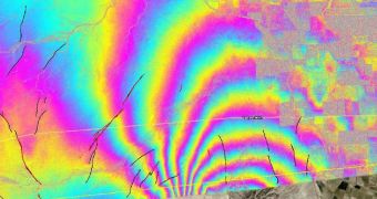
This April, a 7.2-magnitude El Mayor-Cucapah earthquake struck Mexico and the American Southwest, in what was one of the largest tremors to hit the area in more than a century. Studies of the event now indicate that the quake may have boosted seismic risks for Southern California.
At this point, the area is at risk for experiencing even much larger earthquakes than ever before, researchers reported at the 2010 annual fall meeting of the American Geophysical Union, which was held in San Francisco.
A group of US federal agencies, including NASA, presented the batches of data they collected on the seismic event, which was the largest to hit this region in 120 years.
Its effects on the surrounding area were studied using a variety of means, including GPS readings, advanced computer simulation, and remote sensing techniques.
Image analysis techniques that work at unprecedented levels of details were employed to make sense of the overall result, which provided the clearest picture of a quake's aftermath ever produced.
Additional information were collected via airborne light detection and ranging (LiDAR), satellite-based synthetic aperture radar (SAR) and the airborne NASA Uninhabited Aerial Vehicle Synthetic Aperture Radar (UAVSAR).
“This earthquake is changing our understanding of earthquake processes along the Pacific/North American plate boundary, including earthquake physics, forecast modeling and regional faulting processes,” says John Fletcher.
He is a professor at the Center for Scientific Research and Higher Education at Ensenada (CICESE), in Baja California, Mexico. The expert was also the leader of a multi-agency Mexico fault mapping effort.
This included the US Geological Survey (USGS) and the California Geological Survey (CGS).
“The earthquake is among the most complex ever documented along the Pacific/North American tectonic plate boundary,” say experts at the Jet Propulsion Laboratory (JPL), who manage the UVSAR.
“The main shock activated segments of at least six faults, some unnamed or previously unrecognized. It triggered slip along faults north of the border as far as 165 kilometers (about 100 miles) away, including the San Andreas, San Jacinto, Imperial and Superstition Hills Faults,” they add.
Further “data show additional slip along some of the Yuha Desert faults in the months after the main earthquake. Recent data from UAVSAR and satellite radar show this slip slowed and probably stopped in late summer or early fall,” the team reveals.

 14 DAY TRIAL //