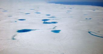
The Greenland Ice Sheet is the second-largest body of land-based ice in the world following Antarctica, and it's destabilizing. Experts say that meltwater produced by surface, or supraglacial, lakes is accelerating the rate at which the ice sheet is normally slipping from the island into the Atlantic Ocean.
The investigation that made this discovery was coordinated by experts at the Cooperative Institute for Research in Environmental Sciences (CIRES), an organization based at the University of Colorado in Boulder (UCB).
Scientists with the team say that water running off these lakes – which form above the ice mass, due to elevated temperatures – is contributing to sea level rise, and that this phenomenon has significant implications for the health of coastal communities around the world.
What is truly dangerous about these lakes is that the water they contain puts pressure on the ice below. As more and more of this ice is melted, the pressure becomes too high, and the ice simply cracks. This leads to the formation of a “drainpipe,” running from the lake to the bedrock supporting the ice sheet.
Liquid water then flows through these drainpipes, lubricating the rocks, and making it easier for the entire ice sheet to slide across the landscape, and towards the ocean. The consequences of the entire Greenland Ice Sheet collapsing and sinking into the Atlantic would be devastating.
“This is the first evidence that Greenland's 'supraglacial' lakes have responded to recent increases in surface meltwater production by draining more frequently, as opposed to growing in size,” says William Colgan, a co-leader of the new study.
The CIRES research associate conducted the investigation with UCB computer science PhD student Yu-Li Liang. Colgan says that the cracking of ices under the pressure of meltwater leads to the formation of “a huge burst of water [that] quickly pulses through to the bed of the ice sheet.”
Details of the research were published in the April 16 online issue of the esteemed scientific journal Remote Sensing of the Environment. Researchers used funds provided by the US National Science Foundation (NSF) Arctic Sciences Program, EurekAlert reports.
Data used by the team span more than 10 years, and cover 1,000+ lakes throughout the GIS. The analysis revealed that each instance of ice cracking under pressure funnels around 1 million cubic meters of meltwater to the bedrock below, within 24 to 48 hours.

 14 DAY TRIAL //