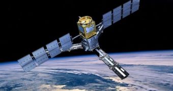
The European Space Agency (ESA) is scheduled to launch the world's first hydrological satellite on November 2, from its Kourou Space Center, in French Guiana, South America. The instrument will be uniquely equipped to analyze moisture levels on the surface of the planet, AlphaGalileo reports. In charge of investigating the data sent back by the space probe will be a team of scientists from the Delft University of Technology, in the Netherlands.
“Soil moisture levels actually form the basis for every hydrologist. Using them, along with other information, you can make decisions on such matters as flooding, drought, desertification and regional weather. Good data on soil moisture levels, however, is scarce. Up to now, you had to go out into the field with a shovel, in a manner of speaking, in order to map out soil moisture levels. That is all going to change with the SMOS (Soil Moisture and Ocean Salinity) satellite,” TU Delft expert, Professor Nick van de Giesen explains.
The main goal of SMOS' mission is to analyze the faint radio waves that are emitted through the top layer of the soil and sea water. According to hydrologists, the strength of these signals can be used as a clear indicator of how much water there is in the soil, information that could, in turn, be used to anticipate floods earlier than currently possible, and also to improve weather forecasts. In spite of the fact that it will do this roughly, SMOS will be the first satellite of this type to perform a global measurement of these readings, ESA officials say.
TU Delft scientists will play a crucial role in calibrating and interpreting the data received from the new satellite. In order “to do so, we will combine the satellite information with a new type of measurement on the ground, among other things. Through fiber optic cables, we will measure the temperature of the soil at several depths. This temperature is an indication of the soil moisture levels,” van de Giesen explains. The expert reveals that SMOS could also be used to determine the levels of salt concentrations in the world's oceans and seas.
Variations in this density produce large-scale ocean currents, which, in turn, have the ability to significantly influence temperature patterns in a large number of areas. Wind-pattern changes can result in glaciers that either melt faster, or much slower, and this can considerably influence the lives of everyone living downstream.

 14 DAY TRIAL //