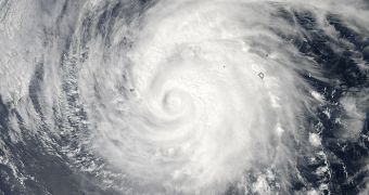
Using the Moderate Resolution Imaging Spectroradiometer (MODIS) instrument on the NASA Aqua satellite, experts are currently keeping track of hurricane Miriam, as it makes its way through the eastern Pacific Ocean.
On September 22, when it formed, Miriam was nothing more than a tropical depression. Just two days later, on September 24, it was already a Category 3 hurricane, weather scientists explain.
MODIS captured this image at 2 pm PDT (2100 GMT) on Monday, in natural colors. At that time, hurricane Miriam was located about 650 kilometers (405 miles) southwest of Baja California.
Yesterday, the US National Hurricane Center (NHC) downgraded it to a Category 2 hurricane. Miriam displayed sustained winds of 160 kilometers (100 miles) per hour, and was heading west-northwest.

 14 DAY TRIAL //