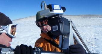
While yardsticks may be sufficiently-suited for measuring snow levels for some applications, they are entirely inadequate for planning vital decisions in terms of transportation, water management and other such situations. Scientists are now using GPS and lasers to develop a new measuring method.
Specialized lasers and advanced Global Positioning System (GPS) technologies are being used together, so that investigators could gain access to a new way of quantifying just how much snow is on the ground at any given time.
The issue with this type of measurement is that the ground is very uneven at most locations, and also that snow is not deposited in an uniform manner. What this implies is that depth measurements, for example, could vary widely ever few meters or so, which hampers any attempt at a precise calculation.
But scientists with the Boulder, Colorado-based National Center for Atmospheric Research (NCAR) believe they may have come up with a way of measuring the amount of snow in a given area.
The prototype devices they are using combine light-pulse technology with satellite tracking data. The hope is that, in the near future, this approach may be used to assess the volume of deposited snow around the planet, not just at a specific location.
“We've been measuring rain accurately for centuries, but snow is much harder because of the way it's affected by wind and sun and other factors. It looks like new technology, however, will finally give us the ability to say exactly how much snow is on the ground,” NCAR expert Ethan Gutmann explains.
Using funds from the US National Science Foundation (NSF), the NCAR team is collaborating with colleagues from the University of Colorado in Boulder (UCB) and the US National Oceanic and Atmospheric Administration (NOAA) for this study.
“Snow represents both a hazard and a water resource in the western states. Both require detailed assessments of snow amounts and depth. This technology will provide new and important guidance,” NSF Hydrologic Sciences Program Director Thomas Torgersen explains.
He adds that authorities usually have to rely almost exclusively on snowfall measurements when making important decisions, such as whether or not to close down highways and airports. Doing so has important economic implications, so the decisions need to be based on the best available data.
Of equal importance is having the ability to predict the risk of an avalanche with a high degree of certainty. At this point, this is mostly guesswork.
“Our hope is to develop a set of high-tech tools that will enable officials to continually monitor snow depth, even during an intense storm. While we still have our work cut out for us, the technology is very promising,” UCB expert Kristine Larson explains.

 14 DAY TRIAL //