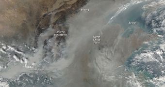
A recently-released image, captured by the American space agency's Aqua satellite, reveals a massive cloud of pollution and haze spreading over China, one of the fastest-developing countries in the world at this time. The massive amount of chemicals that are released in the air by its massive number of fossil fuel-powered electrical plants is combined with the greenhouse gases released by other human activities, and with exhaust plumes from the large fleet of vehicles in the country. The Moderate Resolution Imaging Spectroradiometer (MODIS) instrument on Aqua was used for the new photo.
According to NASA, one of the reasons why this haze is forming above China is an area of temperature inversion. This phenomenon takes place in a situation where you have a layer of warm air on top of cooler air, which doesn't usually happen. There are two types of temperature inversions – surface inversions that occur near the Earth's surface, and aloft inversions that occur above the ground. In the case of the Asian nation, the second type of inversion occurs.
In normal-case scenarios, as you go higher up into the atmosphere, you experience colder and colder air. But, at times, it is possible to encounter an areas of warmer air atop a layer of cooler air. When this happens, pollutants emitted from the planet's surface remain trapped in the cool layer, as its density is higher than that of the air above. This does not allow the two layers to mingle, and contributes significantly to the build-up of atmospheric contaminants close to the planet's surface. If winds are not blowing, this inversion can last up to several days, during which time the territories underneath the phenomenon will appear clouded by a grayish haze.
The new MODIS image was snapped using the instrument's top resolution, of about 250 meters per pixel. It reveals in great detail the areas of eastern China that emit the largest amounts of pollution. Because there are no winds, the chemicals that are released from factories, cars or power plants in a certain area become visible from satellites, or from the International Space Station (ISS). A higher-resolution version of the map can be viewed here.

 14 DAY TRIAL //