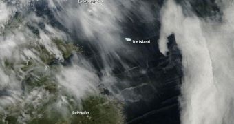
A massive ice island that broke off the Greenland ice sheet nearly a year ago has now been identified off the coasts of Labrador, Canada. The massive iceberg has been drifting in the North Atlantic, posing a danger for navigation, but authorities now know its location.
The object became separated from the Petermann Glacier in Greenland on August 5, 2010, more than 11 months ago. Rather than following a course south, where warmer Atlantic waters would have melted it, the glacier moved west, until it finally traveled all the way across the ocean.
This new image shows a satellite view of PII-A, the name experts gave the massive chunk of ice, as it floats through the Labrador Sea. The natural floating island covers an area of 97 square mile (251 square kilometers), which means that massive amounts of ice must exist under the water.
According to official statistics, this is the largest iceberg to come out of the Petermann Glacier – one of the two largest in Greenland – in more than 50 years. Scientists believe that such a huge chunk got separated because the parent glacier was weakened by the warming of the Atlantic Ocean.
Climate scientists have been warning authorities for years that a warming world would eventually lead to the collapse of major glaciers and ice sheet. Greenland, Antarctica and the Arctic together holds massive volumes of ice, that can raise global ocean levels by several feet.
An important aspect to note is that the Petermann Glacier is one of the two glaciers in Greenland that end in floating shelves, which means that it connects the massive ice sheet covering the island directly to the warmer ocean waters.
This iceberg accounts for 25 percent of the 43-mile (70-kilometer) floating ice shelf of the Glacier. Experts at the University of Delaware estimate it to be about four times the size of Manhattan.
At this point, experts are concerned that losing this chunk of ice has made the ice shelve unstable. They are continuously monitoring its status both from the ground and from satellites. The new view of PII-A, which was snapped on June 25, was collected by the NASA Aqua satellite.
Throughout its1,800-mile (3,000-kilometer) trip, the ice island has been gradually melting. Right now, it weighs between 3.5 and 4 billion tons, and covers an area of about 24 square miles (62 square kilometers), Our Amazing Planet reports.

 14 DAY TRIAL //