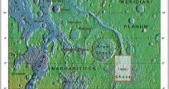
Researchers have managed for the first time, employing data collected with the High-Resolution Stereo Camera (HRSC) onboard ESA's Mars Express spacecraft, to make a topographic map of a Mars' zone.
Iani Chaos region has the first "hiker's map" of the Red Planet, with detailed height contours and geological traits, following the heights of the landscape.
The contour lines depicting similar altitude are superimposed upon HRSC images of Mars.
On Earth, topographic maps are employed by hikers and planning authorities, and every country has its own type (in the UK are named ordinance survey maps).
The data collected by the camera has been analyzed into three-dimensional computer models of Mars, known as the HRSC Digital Terrain Models (DTMs).
The new maps have been realized by a team led by the Principal Investigator G. Neukum (Freie Universit?t Berlin), J. Albertz and S. Gehrke of the Institute for Geodesy and Geoinformation Science, Technische Universit?t Berlin, in cooperation with the German Aerospace Centre (DLR), Institute of Planetary Research, Berlin.
The HRSC DTMs of the Iani Chaos region were employed to make a series of topographic maps at various scales, from 1:200 000 down to 1:50 000.
The astronomers preferred the Iani Chaos region as it was more interesting from a topographical point of view, harboring individual blocks and hills that form a disorganized pattern over the area.
Astronomers believe that these rocks could be the oldest on Mars, being remains of its initial surface.
The areas in between the rock outcrops fell, giving birth to cavities below the surface.
Probably, at the beginning these cavities were supported by ice, which melted due to volcanic activity and the water resulted flowed out into Ares Vallis, to the Mars' northern plains.
The contour lines are employed like in any topographical to read the morphology of the surface, each line depicting in most maps a variation of 250 meters in height.
These maps also present the names of geographical traits and the lines representing longitude and latitude on the planet.
Soon, the data provided by the HRSC will enable the scientists to realize the mapping of the whole planet, a total of 10 372 particular map sheets, for equal areas on the planet, at a scale of 1:200 000.
Achieving this goal requires a comprehensive program at the European level.

 14 DAY TRIAL //