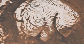
Researchers at the NASA Jet Propulsion Laboratory (JPL) in Pasadena, California, announce that they were recently able to obtain new and detailed data on how the Martian ice caps look like. The formations are not readily visible, as they are covered with a thin layer of red dust, but instruments on the Mars Reconnaissance Orbiter (MRO) have proven able to penetrate to it. Especially useful in this research was the Shallow Radar (SHARAD) instrument, which gave scientists a new understanding on how climate change evolved on Mars, and what its effects were.
More than 40 years ago, astronomers discovered a large chasm at the planet's North Pole, which also featured a series of spiral troughs around. Since then, experts have been trying to make sense of these formations, but thus far to no success. With SHARAD, the JPL group was able to collect sufficient data on the structures to reconstruct their formation process. In addition to providing further insight into the geology of the Red Planet, the investigation may also shed more light on the climate changes that eventually led to Mars becoming the desolate, barren landscape it is today.
“SHARAD is giving us a beautifully detailed view of ice deposits, whether at the poles or buried in mid-latitudes, as they changed on Mars over the last few million years,” explains JPL MRO project scientist Rich Zurek. He adds that additional data of the two studies conducted with data from the orbiter appear in the May 27 issue of the top-ranked scientific publication Nature. “Nobody realized that there would be such complex structures in the layers, The layers record a history of ice accumulation, erosion and wind transport. From that, we can recover a history of climate that's much more detailed than anybody expected,” adds University of Texas at Austin Institute for Geophysics expert Jack Holt.
He is the lead author of the paper analyzing the Chasma Boreale structures. This is a canyon of sorts, about the size of the Grand Canyon in the United States, but significantly deeper and wider. There are currently no clear explanations for how it was formed, but some experts say that it was produced following volcanic activity. Others say that strong winds carved it out of the ices. The second study covers the troughs. Discovered decades ago, these landscape features make the entire, Texas-sized Martian ice sheet look like a pinwheel. The processes that led to their formation are still highly-debated in the international scientific community.
“These anomalous features have gone unexplained for 40 years because we have not been able to see what lies beneath the surface. It is gratifying to me that with this new instrument we can finally explain them,” concludes University of Rome Shallow Radar team leader Roberto Seu.

 14 DAY TRIAL //