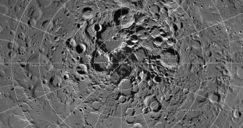
Officials with the American space agency announce the creation of the most detailed mosaic image ever assembled to cover the north pole on the Moon. The dataset was created using photos collected by several camera instruments aboard the NASA Lunar Reconnaissance Orbiter (LRO). The high-resolution mosaic will soon help planetary scientists understand lunar topography in more detail.
The large image features a resolution level of 2 meters (6.5 feet) per pixel and covers an area roughly equal to a quarter of the continental United States. The entire dataset features around 10,580 images that have been painstakingly stitched together to form a unified view of the lunar north pole.
One of the most difficult aspects of the effort was for the LRO to snap the majority of these images from a consistent angle, so that lighting patterns were maintained throughout the dataset. This now enables viewers and researchers to notice subtle shadings in the observed areas, which then reveals the true textures of the polar region.
The entire image contains around 867 billion pixels in total, or 931,070 pixels square. Printing this image at a resolution of 300 dots per inch, which is standard in printing, would require a football field-sized sheet of paper. Storing the dataset on a computer would require around 3.3 terabytes of space.
NASA experts say that most of the images were taken using the two LRO Narrow Angle Cameras (NAC), which are themselves part of the Lunar Reconnaissance Orbiter Camera (LROC) suite. This instrument is well-suited for photographing a wide dynamic range of lit and darkened areas.
“This unique image is a tremendous resource for scientists and the public alike. It's the latest example of the exciting insights and data products LRO has been providing for nearly five years,” comments LRO project scientist John Keller, who holds an appointment with the NASA Goddard Space Flight Center (GSFC) in Greenbelt, Maryland.
“Creation of this giant mosaic took four years and a huge team effort across the LRO project. We now have a nearly uniform map to unravel key science questions and find the best landing spots for future exploration,” adds LROC principal investigator Mark Robinson, who is based at the Arizona State University (ASU) in Tempe.
LRO has been investigating the Moon since achieving orbital insertion around Earth's natural satellite, on June 23, 2009. The spacecraft was launched into space on June 18, 2009, aboard an Atlas V 401 delivery system, from Space Launch Complex 41 at the Cape Canaveral Air Force Station, in Florida.
Joining LRO on its way to the Moon was the Lunar Crater Observation and Sensing Satellite (LCROSS) experiment, which was basically the spent Centaur upper stage of the Atlas V rocket that carried the mission into space. The impactor struck the lunar surface on October 9, 2009, and successfully revealed the presence of water-ice in permanently-shadowed craters on the Moon.

 14 DAY TRIAL //