Street View has been one of Google's most popular and most controversial projects to date. But despite setbacks, Google is pushing forward and has now announced that Street View is available on all seven continents.
"We introduced Street View back in May 2007, enabling people to explore street-level imagery in five U.S. cities," Brian McClendon, VP of Engineering, Google Earth and Maps wrote.
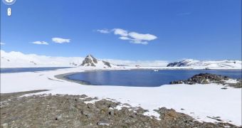
"Three years later, we’re happy to announce that you can now explore Street View imagery on all seven continents, with the addition today of Brazil, Ireland and Antarctica," he announced.
"You can now see images from around the world spanning from the beaches of Brazil, to the moors of Ireland, to the icy terrain in Antarctica," he said.
In one fell swoop, Google Street View now covers the entire world. Granted, there isn't a whole lot of imagery for each continent out there, in Antarctica, for example, it just covers some regions of the Half Moon Island.
But you can visit places from all over the world and get an eye level view, quite a feat for a product that launched just three years ago.
Unlike most of the places it launches today, there doesn't seem to have been a lot of complaints coming from Antarctica. No penguin asked for their home to be removed from Street View or even have its face blurred.
It seems penguins are a bit more relaxed about their privacy than other inhabitants of this planet.
A cute touch is that Pegman, the little stick man figure which you can drag around to move from location to location in Street View, changes to a little penguin when you're using it in the region of Antarctica covered.
And if you want to venture further into the frozen wilderness, there are also quite a few spectacular user photos in Antarctica as well.

 14 DAY TRIAL //