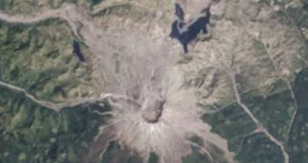
Using data from the Landsat satellite constellation, experts at the American space agency have recently created a new time-lapse video of Mount St. Helens and the surrounding areas, showing how life recovered following the volcano's massive, May 18, 1980 eruption.
The event saw the entire northern face of the mountain being destroyed, and the release of a 24,400-meter (80,000-foot) high plume of ash and other debris into the atmosphere. Thousands of animals and 57 people were killed. The event caused around $2.74 billion in damages.
The death toll could have been hundreds of times higher, were it not for the intervention of scientists from the United States Geological Survey, who convinced local authorities to close down the mountain, even though huge pressure was exerted to reopen it to the public.
When the mountain blew up, all of its glaciers and ices were melted, which led to the creation of massive lahars. These volcanic mudslides were the largest ever recorded in human history, and reached distances up to 80 kilometers (50 miles) from the mountain.
Hundreds of square miles of land were reduced to rubble, while entire ecosystems were thrown off balance, and numerous habitats destroyed. The Landsat satellites were used to monitor the devastation, producing images centered on the top of the mountain.
Images were collected between 1979 and 2011, and included in the time-lapse video below. This 30-year study provided investigators with a unique chance to study how life recovers from cataclysmic events. Data collected from this survey could reveal how life recovers from extinction events.
“This image was created using the reflected light from the near infrared, green and red portions of the spectrum from instruments aboard Landsat satellites 2 and 3 and from the blue, green and red portions of the spectrum from instruments aboard Landsat satellites 5 and 7,” NASA experts say.
“The landslide buried 14 miles (23 kilometers) of the North Fork Toutle River with an average of 150 feet (46 meters) of rocks, dirt and uprooted trees. In some places the debris was as deep as 600 feet (180 meters) high,” the statement adds.
The new video again demonstrates the usefulness of the Landsat constellation in understanding forest health, storm damage, agricultural trends, urban growth and other changes affecting the landscape, Astrobiology Magazine reports.

 14 DAY TRIAL //