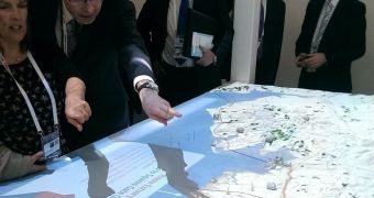
Maps are serious business, but they aren't nearly as hard to draw these days as they used to be. Mostly because no one has to write or paint them by hand anymore.
There are still challenges associated with them, however, such as rendering them in appropriate size. Or making them so large that they leave all other maps completely in the dust. It is a great way to turn heads and make an impression.
Hobs Studios decided to do just that: make an impression. Its method? Creating the largest ever map of England’s Northwest.
Well, that wasn't the only motivation though. One of the world’s largest structural design firms, called ARUP, actually commissioned the map.
Hobs Studio did it thanks to the help of 3D printing technology. It's not a normal map either, but one which shows how renewable energy harvested through tidal gateways can be utilized along England’s Northwest coast.
In fact, the map includes over 130 3D-printed models of renewable energy sources, like coal power stations, nuclear plants, hydro turbines, and so on. Projectors situated above the map even beam video footage of tides, making it look almost holographic.
All in all, the map measures 3.4 x 1.6 meters / 11 x 5 feet and includes everything from North Wales to the Lake District (a mountainous region in northwest England), plus the Peak District. It will be shown off at the Festival of Business in Liverpool, England, until the end of July, at which point it will be broken into 8 parts and used as necessary.

 14 DAY TRIAL //