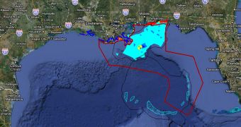
Investigations conducted by American researchers in the Gulf of Mexico have determined that a large plume of crude oil has made its way into a corner of the Loop Current. This is a deep-water current that passes through the Gulf, heading east towards Florida, and then onwards into the Gulf Stream. Experts from the Miami Cooperative Institute for Marine and Atmospheric Studies (CIMAS) and the US National Oceanic and Atmospheric Administration (NOAA) Atlantic Oceanographic and Meteorological Laboratory (NOAA/AOML) carried out the studies, using funds from the US National Science Foundation (NSF) and advanced research equipments and vessels.
The team surveyed an area located in the counterclockwise rotating frontal eddy of the northeast corner of the Loop Current. The researchers hypothesized that, once the oil had reached this location, it would head south along the eastern frontal zone of the Loop Current, and move to the Dry Tortugas. The area revealed oil sheens, but no tar balls, as previously thought. However, after moving south, the team encountered a large concentration of oil, in a new slick. They used the University of Miami's 96-foot catamaran the RV/F.G. Walton Smith for this investigation, and were also aided by aerial survey data provided by the US Coast Guard (USCG).
“As we approached, we found an extensive oil slick that stretched about 20 nm (20 miles) along the southward flowing jet which merged with the northern front of the Loop Current. The slick was made up of tar balls shaped like pancakes that went from the size of a dime to about 6 inches in diameter. The combination of models and satellite images, along with our shipboard observations and ROFFS [Roffer's Ocean Fishing Forecast Service] daily analysis had helped us to identify and study this previously unidentified oil plume located off Florida's southwest coast and heading toward the Tortugas,” explains CIMAS research scientist Tom Lee, who is also a professor emeritus at the University of Miami.
“The good news is that the various approaches we are using to project its pathway seem to be yielding similar answers and guiding us properly. We need to maintain our vigilance and expand our efforts to determine the degree of risk to unique downstream resources like the Dry Tortugas and Florida Keys National Marine Sanctuary, which are vital natural environments that we need to protect. NOAA Cooperative Institutes, like CIMAS, continue to stand ready to assist their federal partners with the best available science to ensure that response and restoration resources are deployed as proactively and responsibly as possible during this national emergency,” says UM marine biology and fisheries professor Peter Ortner, who is also the director of CIMAS.
The Deepwater Horizon semi-submersible drilling rig, which operated only tens of miles south of the coasts of Louisiana, suffered a large explosion on April 20. Eleven crew members are assumed dead, and all rescue efforts aimed at finding them have long since been called off. On April 22, the rig sunk into the waters of the Gulf, in spite of the fact that emergency response ships were on-site, evacuating workers, and pouring water on the platform. With the collapse of the Horizon, the pipes that carried the oil from a depth of 5,000 feet (1,500 meters) broke.
The valves designed to stop the oil flow in such an instance malfunctioned, and thousands of barrels of crude have been spilling in the water daily ever since. Actual amount may be a lot larger than this, experts warn, which means that the damage may be considerably larger than initially estimated. Given the size of the slick, some hypothesize that the oil may have moved from the site in underwater plumes, which are extremely difficult to detect, even with sensitive Earth-observing satellites.
“As part of the federal government's ongoing response to the BP spill, the Environmental Protection Agency (EPA) continues its extensive air quality monitoring along the Gulf Coast. In this case, NOAA and EPA are working collaboratively to take advantage of NOAA’s highly specialized atmospheric research capabilities, which can detect concentrations of compounds in the atmosphere with greater sensitivity than standard operational monitoring flights. The P-3 is currently involved in a major climate and air quality study in California, called Calnex, which is why it is already properly outfitted for this emergency gulf mission. Another NOAA P-3 is also in the Gulf and has done multiple flights to help monitor the location of the Loop Current,” NOAA officials said in a statement.

 14 DAY TRIAL //