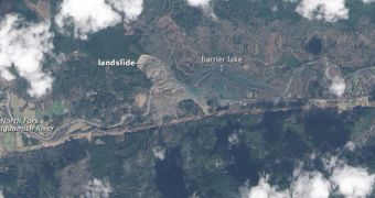
Scientists at NASA and the United States Geological Survey were recently able to capture a new image of the landslide that occurred near Oso, in Washington, on March 22, 2014. In order to get the best-resolution photographs, the team used the Operational Land Imager (OLI) instrument aboard the Landsat 8 satellite for the job.
According to geologists, the landslide most likely occurred due to significant rainfall the previous weeks. Tons upon tons of debris were moved into the North Fork of the Stillaguamish River, as the landslide destroyed several homes in its path. Authorities say that at least 14 people have been caught unaware, and killed, by this natural disaster.
A report released on Tuesday, March 25, indicated that 176 people were unaccounted for. Search efforts continue in the area, though several days have passed since the disaster, and chances of recovering survivors are slim. The landslide was so significant that it blocked the river, creating a barrier lake that is held in place by an earthen dam.
Landsat 8 used OLI to capture the image above on Sunday, March 23. The photo reveals the potential for a flash flood in the area, in case the barrier lake manages to break through the dam. The US National Weather Service has already issued a flash flood alert for most of Snohomish county, which was still in effect on Tuesday. The same area suffered landslides in 1988, and again in 2006.

 14 DAY TRIAL //