Climate scientists know that couple, ocean-atmosphere processes in the Pacific Ocean can have a tremendous influence of climate patterns worldwide. These events, called El Niño and La Niña, alternate with each other, but their cycles have pauses called La Nada. This is where we are now.
A couple of months ago, experts began to see that La Niña was clearly dissipating. As they conducted the observations, they noticed that indeed this was the case. By earlier this month, the process had disappeared entirely, leaving no traces behind.
But the switch from La Niña to El Niño does not occur immediately, NASA Jet Propulsion Laboratory (JPL) oceanographer and climatologist Bill Patzert explains. He calls this transition period we're in La Nada, which roughly translates into “the nothing.”
Data collected by the US-French Ocean Surface Topography Mission (OSTM)/Jason-2 oceanography satellite have revealed that equatorial Pacific sea surface heights have been stable and near average.
When either of the two phenomena are active, these waters become either too warm or too cold. These shifts are all part of the El Niño-Southern Oscillation climate pattern, which has implications for ecosystems, precipitation patterns and other global climate factors.
“Elsewhere, however, the northeastern Pacific Ocean remains quite cool, with sea levels much lower than normal. The presence of cool ocean waters off the US West Coast has also been a factor in this year's cool and foggy spring there,” a JPL press release reads.
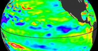
The image attached to this article shows the state of temperature levels across the Pacific Ocean on June 18, as seen by OSTM/Jason-2. Yellow and red represent warmer temperatures, while blue and purple indicate the presence of cooler waters.
Green shows areas that have temperatures closer to the normal average for this time of year. The reason why ocean surface temperature is so important is that it indicates precisely how much sunlight has been trapped in the upper layers of the world's ocean.
Now, Patzert says, La Nada is controlling the Pacific, meaning that nothing is going on. However, that will change over the coming months, as El Niño prepares to take over.
“For the United States, there would be some positives to the appearance of El Niño this summer. The parched and fire-ravaged southern tier of the country would certainly benefit from a good El Niño soaking,” he explains.
“Looking ahead to late August and September, El Niño would also tend to dampen the 2011 hurricane season in the United States. We've had enough wild and punishing weather this year,” he adds.
“Relief from the drought across the southern United States and a mild hurricane season would be very welcome,” Patzert concludes.

 14 DAY TRIAL //