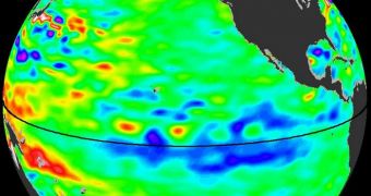
Recent observations conducted with the NASA Jason-1 and -2 satellites have revealed that La Niña is returning to the tropical Pacific Ocean. This coupled, ocean-atmosphere phenomenon can cause severe weather disruptions throughout North America and, to a lesser extent, the entire world.
It is caused by shifts in sea surface temperatures in equatorial portions of the Central Pacific Ocean. Just before a La Niña event is triggered, temperatures usually drop by 3–5°Celsius from normal values.
Usually, it takes about 5 months for such an event to subside, and get replaced by its opposite, El Niño. The latter also causes widespread climate change over multiple areas, but these changes are the exact opposite to those caused by La Niña.
Experts at the NASA Jet Propulsion Laboratory (JPL), in Pasadena, California, explain that a peaking La Niña will cause the Pacific Northwest to become a lot more stormy during the remainder of the winter, and throughout spring.
Conversely, the southern and southwestern parts of the United States will become increasingly dry, with huge chances of important droughts affecting crops next summer. Over the past two years, La Niña conditions have prevailed, with only minor El Niño interferences.
Before the new study, experts thought that only a milder version of last year's La Niña was occurring. The latest satellite readings indicate that the phenomenon is currently intensifying. The two Jason spacecraft collected their data over a period of 10 days.
The dataset was centered on January 8, 2012. What this map shows are areas of the Pacific Ocean where the sea surface is higher than usual (yellow/red), mostly due to higher temperatures, but also regions where the surface dropped below normal values due to cooler temperatures (purple/blue).
According to statistics, this is the second year in a row when altimetric data from the Jason spacecraft reveal lower-than-normal sea surface heights in the areas of the Pacific where La Niña and El Niño originate.
“Conditions are ripe for a stormy, wet winter in the Pacific Northwest and a dry, relatively rainless winter in Southern California, the Southwest and the southern tier of the United States,” JPL climatologist Bill Patzert explains.
“After more than a decade of mostly dry years on the Colorado River watershed and in the American Southwest, and only two normal rain years in the past six years in Southern California, low water supplies are lurking,” he goes on to say.
“This La Niña could deepen the drought in the already parched Southwest and could also worsen conditions that have fueled recent deadly wildfires,” the investigator concludes.

 14 DAY TRIAL //