14 DAY TRIAL //
 Having recently maneuvered into its 50-kilometer mapping orbit around the Moon, NASA's Lunar Reconnaissance Orbiter (LRO) is now able to snap amazing, high-detail photos of features that have only been hinted at by other orbiters around the satellites until now. The switch from one orbit to the other took place on September 15 and, since then, the probe has been using its instruments to snap more photos of the lunar surface, and to compare them with others, taken while the craft has been in another orbit.
One such target for observation has been the Apollo 17 landing site, which has been set photographed in the largest level of detail ever in the new image. According to the team managing the LRO, the new images are at least two times clearer and more detailed than any others. In the photos attached to this article, you can clearly see the wealth of details that is visible around the landing site. The flag itself can be seen from this low orbital altitude, as well as some of the most important landscape features that were made popular during the actual mission.
The new photos were snapped as the Sun was at a 28-degree-incidence angle, high in the sky. This enabled the advanced instruments aboard the LRO to make out the subtle nuances in brightness variations registered at the surface. The photos have an angular resolution of no less than 50 cm per pixel, which means that the lunar module Challenger is clearly visible. The descent stage base can also be seen, 8 pixels across, its legs distinguishable too. The base from which the ascent stage took off is four meters across. The spacecraft met up with the command module America on December 14, 1972.
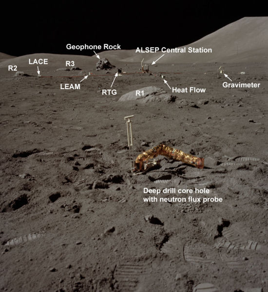
The photographs also reveal the Apollo Lunar Surface Experiments (ALSEP). These scientific research payloads included four sections in the Apollo 17 mission. The first was the Lunar Seismic Profiling Experiment, or the geophones. The Lunar Atmospheric Composition Experiment (LACE) was the second, and it was designed to measure the composition of the Moon’s extremely tenuous, surface-bound exosphere. The Lunar Ejecta and Meteorites (LEAM) experiment, the third ALSEP, was supposed to analyze the ejecta cones generated by incoming asteroids or meteorites.
The experiment suit also included a central station and a heat-flow experiment. All of the instruments were powered by a Radioisotope Thermoelectric Generator (RTG), according to NASA records of the flight. The last image shows the base, as photographed by the Apollo 17 astronauts themselves.