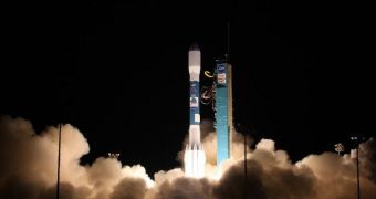
When the National Polar-orbiting Operational Environmental Satellite System (NPOESS) Preparatory Project (NPP) satellite launched to space on October 28, it also carried a number of five smaller CubeSats. One of these probes is carrying an experiment developed by the Jet Propulsion Laboratory.
The instrument is installed aboard the Michigan Multipurpose Mini-satellite M-Cubed, and is called the CubeSat On-board processing Validation Experiment. Experts refer to it as M-Cubed/COVE. The small satellite was developed by experts at the University of Michigan.
The JPL instrument is meant to test technologies that experts want to use for future NASA Earth science missions. It is capable of obtaining mid-resolution color images of the planet's surface, but also of analyzing the impact of aerosols and clouds on Earth's climate.
These capabilities are in tune with the overall theme of the NPP satellite, which was also launched to provide scientists with improved data-gathering abilities for long-term climate modeling. In addition, the NPOESS test vehicle can also be used for short-term weather forecasts.
The Delta II delivery system that carried NPP to orbit also contained five auxiliary CubeSats, which were launched to space as part of the NASA Educational Launch of Nanosatellite mission (ELaNa III).
JPL investigators say that COVE will also have to validate advanced image processing algorithms that were developed by next-generation, Earth-observing NASA satellites. The Aerosol-Cloud-Ecosystem (ACE) mission is the most likely candidate to carry an instrument modeled on COVE algorithms.
Experts say that one of the main instruments on ACE will be a multi-directional, multi-wavelength, high-accuracy polarization camera system, which will be called the Multiangle Spectro-Polarimetric Imager (MSPI). In order to create images, this system will need to feature advanced algorithms.
The instrument itself is a developed, refined version of the NASA Terra satellite's Multi-angle Imaging SpectroRadiometer (MISR) tool, which was also developed by JPL. The team has already produced a MSPI prototype, which is called AirMSPI.
As the name implies, this test model of the camera system is currently being tested aboard a NASA ER-2 high-altitude aircraft. The NASA Earth Science Technology Office, in Washington DC, funds both M-Cubed Cove and MSPI.
At this point, COVE is still not operational, due to the fact that M-Cubed has not yet gone through all stages of in-orbit testing and commissioning. Once this is done, mission controllers will initiate COVE operations, and begin collecting relevant data.

 14 DAY TRIAL //