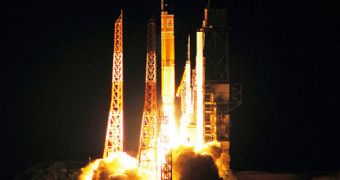
The foundation of the Japanese Quasi-Zenith Satellite System has just been laid with the launch of a new navigations satellite, nicknamed Michibiki. The spacecraft took off Saturday from the Tanegashima Space Center (TSC).
The facility is located on the southernmost of Japan's main islands, Kyushu. The Yoshinobu launch complex at the shoreline facility was used as a starting point for the new mission.
This is the first satellite of the new constellation, and its name means “guiding,” or “showing the way” in Japanese. The QZSS satellites are meant to provide refinement for existing navigations capabilities.
Due to the fact that many mountains and skyscrapers are continuously interfering with the quality of navigations signals throughout Japan, the country's Aerospace Exploration Agency (JAXA) decided to launch four satellites to improve these abilities.
The Asian nation is currently heavily dependent on measurements provided by the United States' Global Positioning System (GPS). But the US does not provide quality signals for civilian and international customers.
In other words, only the US military benefits from the full capabilities of the GPS. The Japanese decided to build the new, four-satellite constellation in order to augment whatever signals they do receive.
In skyscraper-filled cities like Tokyo, trying to navigate via GPS is rather useless, due to massive amounts of interferences caused by the tall buildings.
Through strategic satellite positioning in the skies above Asia, JAXA hopes to be able to make urban GPS navigation feasible.
At this time, the American-built service provides 90 percent coverage in Japan, but a finished QZSS system would raise that to 99.8 percent.
Michibiki was launched atop a 17-story-high H-2A rocket at 1117 GMT. An extra energy boost was ensured by two 49-foot solid rocket boosters (SRB), Space reports.
The satellite is estimated to take about two weeks until it reaches its final destination orbit, officials at JAXA announced.
Its orbit will have 45-degree inclination to the Equator, and will have a height of 24,000 miles. This is more than twice the altitude of GPS satellites, which fly at 11,000 miles.

 14 DAY TRIAL //