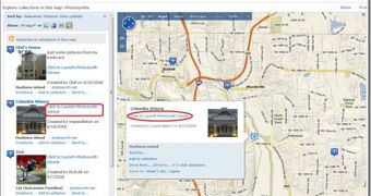
Live Search Maps/Virtual Earth has grown with the integration of content from Photosynth. Essentially, Microsoft is now integrating synths into its mapping, location and search platform. This means that Virtual Earth users will no longer be able to explore only aerial, Bird's Eye and satellite imagery, but also 3D environments put together with 2D pictures with various locations around the world, namely synths. Microsoft has blended together two of its services making available Photosynth content from Live Search Maps.
“In order to find Photosynths in Live Search Maps you’ll search for a location. In the welcome pane, you’ll see a link for 'Explore Collections' which you click and begin seeing all kinds of collections. You can then improve your search using a helpful toolbar based on tags, collections with photos, collections with 3D models, collections with MapCruncher layers, and collections with Photosynths! Additionally, you can sort these by relevance (if you input a search term), distance from the center of the map, date added and last updated,” explained Chris Pendleton, Virtual Earth Tech Evangelist.
But unlike the now traditional imagery that is associated with Virtual Earth and Live Search Maps, and controlled exclusively by Microsoft, end users themselves will be able to build synths of areas around the world and then permit their integration into the Redmond giant's mapping platform. Once indexed, the synths will be returned with the results for queries in Live Search Maps, Microsoft informed. Users will subsequently be redirected to Photosynth in order to view the synth that they found via Live Search Maps.
“If you’ve made any Photosynth’s you can go back to Photosynth.com, login with your Window’s Live ID and give the Synth a placement on the map. This will index into Live Search Maps and people will find your synths,” Pendleton added.

 14 DAY TRIAL //