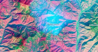
Researchers at NASA recently demonstrated that it is possible to use the Advanced Land Imager (ALI) instrument on the NASA Earth Observing 1 (EO-1) satellite to see through wildfires.
For this purpose, they turned their attention to the Mustang Complex fire raging through the Salmon-Challis and Bitterroot National Forests, in Idaho. ALI snapped multi-wavelength images of the thick smoke cloud that were released by the fast-burning fires.
While the optical components of the image showed only thick smoke, entirely obscuring the surface, the infrared data were able to see right through this obstacle, as visible in the image above.
The color-coding for this photo is very simple – green marks vegetation that was unaffected by the fire on September 18 (when the image was collected), while red and purple hues show the most severely affected areas.

 14 DAY TRIAL //