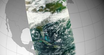
NASA officials announce that the main infrared instrument on the National Polar-orbiting Operational Environmental Satellite System (NPOESS) Preparatory Project (NPP) satellite has recently been brought online, and that it has already conducted its first measurements.
NPP is one of the most advanced Earth-observing satellites ever developed. The NPOESS project for which it was developed has been shut down since work on the spacecraft began, but that did not stop a consortium of governmental agencies and universities from building it all the same.
After numerous delays, NPP was finally launched to orbit on October 28, from the Vandenberg Air Force Base (VAFB), in California. It was carried to its orbital perch aboard a Delta II delivery system.
Days after successfully reaching its intended destination, its instrument began being brought online one after another. The latest in this series was the Visible Infrared Imager Radiometer Suite (VIIRS), the main IR instrument aboard the spacecraft.
It managed to acquire its first high-resolution image of the planet on November 21, demonstrating that it is functioning properly, and also providing some hints as to its capabilities. The photo it produced stretches from the northern coasts of Venezuela, through Florida, up to the Hudson Bay.
The first data package VIIRS sent back to Earth were processed at the US National Oceanic and Atmospheric Administration (NOAA) Satellite Operations Facility (NSOF). The installation is located in Suitland, Maryland.
“This image is a next step forward in the success of VIIRS and the NPP mission,” explains NPP project scientist James Gleason. He holds an appointment at the NASA Goddard Space Flight Center (GSFC), in Greenbelt, Maryland.
“VIIRS heralds a brightening future for continuing these essential measurements of our environment and climate,” adds NASA Headquarters NPP program scientist Diane Wickland. The official estimates that all instruments on NPP will be up and running before the year is out.
The reason why this instrument is so important is that it will be able to survey aspects such as wildfires, ice, ocean color, vegetation, clouds, and land and sea surface temperatures. In order to do this, it will use 22 IR channels, spread out across the infrared portion of the electromagnetic spectrum.
VIIRS is the largest of five instruments NPP carries, tipping the scales at around 252 kilograms (556 pounds).
“Along with VIIRS, NPP carries four more instruments that monitor the environment on Earth and the planet's climate, providing crucial information on long-term patterns to assess climate change and data used by meteorologists to improve short-term weather forecasting,” GSFC NPP project manager Ken Schwer concludes.

 14 DAY TRIAL //