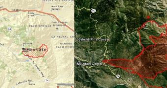
The Idyllwild fire in the San Jacinto Mountains is spreading, and a mapping of the perimeter over three days shows the alarming rate at which it is increasing.
The image to the left depicts how large it was on Monday, when it popped up in Riverside county. Officials are calling the incident the “Mountain Fire,” referencing the area where it was first spotted.
The map to the right depicts the status of the fire yesterday, as relayed by Timeless Environments.
As I mentioned earlier, the blaze is now threatening 4,100 homes, hotels, and cabins and thousands of evacuations have been made in the area.
Seven homes have been leveled and cars and sheds have been destroyed. Firefighters describe that the blaze is reacting like a September or October fire.

 14 DAY TRIAL //