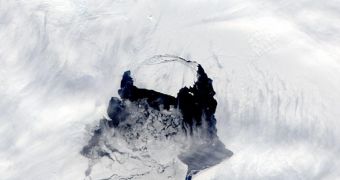
An iceberg that separated from the Pine Island Glacier, on Antarctica western ice sheet, is giving researchers a headache. The massive block of ice may be heading into heavily-traveled shipping lanes, which is why emergency funds have just been released to outfit the iceberg with GPS devices.
Earth system scientists in the United Kingdom recently received some $80,000 (60,000 euros) to begin conducting monitoring operations on this piece of ice. According to the latest measurements, the iceberg covers an area of about 700 square kilometers, or 270 square miles.
If it were to wander off into busy shipping lanes, it would essentially obliterate any vessel it comes across, regardless of the latter's size or tonnage. This is why the British research team will install a series of Global Positioning System (GPS) transponders on the massive ice chunk.
Data collected from these sensors will be used to inform ship captains in its vicinity about any impending risk of collision. The transponders will most likely remain on the glacier until it melts away in the southern Atlantic Ocean, or in the Indian Ocean, ArsTechnica reports.
The first signs that the iceberg was calving from the Pine Island Glacier were detected by NASA satellites back in 2011, but the breakaway process lasted for a very long time. It was not until this July that spacecraft finally imaged a clear separation between the two.
“The iceberg remained attached to the glacier for four months [after this] because it had been winter in the southern hemisphere and the iceberg is likely to have been frozen against the glacier,” University of Sheffield professor Grant Bigg says.
“We expected it to break-away but did not know when this would occur. From satellite images you couldn't see much evidence of the split widening until November 11,” he goes on to add.
Experts say that the iceberg is roughly 8 times larger than the entire island of Manhattan, in New York City. The reason why this emergency grant was awarded is that no one knows for certain what trajectory the mountain of ice is currently following.
“We know from previous giant icebergs and from preliminary modeling experiments, that this is a sensitive area of the Southern Ocean circulation where icebergs can either move westwards along the coast or loop out into the Southern Ocean and become entrained in the eastward flowing Circumpolar Current,” Bigg explains.
The GPS data collected from the transponders will be used to recreate the path the iceberg takes over the world's oceans. This could help planetary scientists gain additional insights into how these floating ice fields live out their final days, before finally melting in warm waters.

 14 DAY TRIAL //